India Guide · Regions
North India: Mountains, Empires and the Great Plains
Fertile enough to build an empire on, open enough that everyone eventually tried.
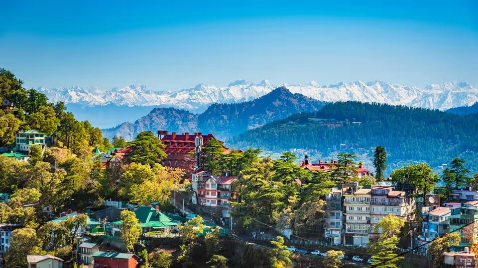
Himalayan Foothills
If Rajasthan is a story about scarcity, and Eastern India is a story about rivers finally reaching the sea, North India is a story about a different kind of geography altogether: plains fertile enough to build an empire on, and open enough that almost everyone eventually tried.
This is the region most itineraries already run through — Delhi, Agra, the Golden Triangle. Understanding why empires kept converging here makes that itinerary mean something more than a checklist.
The mountains that started everything
The Himalayas form the northern edge of this region, and they’re not just a scenic backdrop above the plains — they’re one of the reasons the plains exist at all. Snowmelt and monsoon rain feed the rivers that descend from these mountains, and those rivers are what turned the land below into some of the most fertile agricultural territory on Earth.
The mountains shaped things less directly, too: passes controlled who could enter from the northwest, high-altitude pilgrimage routes shaped religious geography, and the sheer scale of the range meant that whatever happened on the plains below was, in a real sense, downstream of what happened in the mountains above.
The great northern plain
South of the mountains lies the Indo-Gangetic plain — one of the largest, flattest, most continuously farmed stretches of land in the world, fed by the Ganga, Yamuna, Ghaghara, Gandak and Kosi rivers.
This fertility did something specific: it supported a population large enough, and wealth concentrated enough, to build and sustain empires. Cities grew along these rivers for the same reason cities grow anywhere water and farmland meet — but here, the scale of both was extraordinary enough to make the northern plains the demographic and agricultural heartland of the subcontinent for millennia.
Why so many empires came here
Fertile land, a large population and river-based trade routes make a region wealthy. They also make it worth fighting over — and North India has spent much of its history being exactly that: wealthy enough to be worth conquering, and open enough, geographically, that conquering it was actually possible.
Unlike Rajasthan’s deserts or the high Himalayas further north, the northern plains offer relatively flat, open terrain — good for agriculture, but also good for moving armies. That combination, fertile and accessible, is the geographic logic behind nearly every empire that rose here: the wealth funded them, and the terrain let them move.
The same geography that made the region wealthy also made it worth fighting over.
The northwest gateway
To the northwest, mountain passes — the Khyber and Bolan among the most significant — connected the plains to Central Asia and Persia. For centuries, these passes were the route through which merchants, migrants, armies and ideas entered the subcontinent.
It’s tempting to reduce this history to a story of invasions, but that undersells what actually happened: trade goods, religious ideas, artistic styles and entire vocabularies moved through these passes as often as armies did. Persian and Central Asian influence on North Indian language, cuisine and art didn’t arrive only through conquest — it arrived through centuries of contact that conquest was only one part of.
Delhi: a capital that kept re-forming
Ask why Delhi is India’s capital and most people answer with a fact: it’s the seat of government. That’s true, but it dodges the more interesting question — why Delhi kept becoming a capital, dynasty after dynasty, for the better part of a thousand years.
The location itself explains a lot: positioned near the Yamuna, close to the routes coming through the northwest passes, and sitting at a natural crossing point of the northern plains, Delhi occupied a genuinely strategic position long before any particular empire chose it. The Delhi Sultanate built there. The Mughals rebuilt there. The British, after ruling from Calcutta for over a century, eventually moved their capital there too, constructing New Delhi in the early 20th century. Each version of Delhi was built partly on the ruins of the last — which is part of why the city today holds so many layers of history within a fairly compact area.
Why Delhi, again and again
The city’s position — river access, proximity to the northwest trade and invasion routes, and a natural chokepoint on the plains — made it a strategically obvious capital for almost a thousand years of very different rulers, long before it became independent India’s capital too.
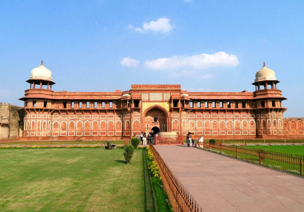
Red Fort Agra
The Mughal world
The Mughal Empire, at its height, connected Delhi and Agra to a cultural world that reshaped North India: distinctive garden architecture, a new administrative language and system, Persian-influenced art, and a cuisine that blended Central Asian, Persian and Indian traditions into something new.
Urdu itself, still one of the major languages of North India, developed out of exactly this contact zone — a mixture of local languages with Persian and Arabic vocabulary that emerged in and around Mughal courts and armies. The empire’s architectural legacy is probably its most visible today, but the linguistic and culinary legacy runs just as deep, still shaping everyday life in the region centuries later.
Sikhism and Punjab
Punjab takes its name from the Persian for “five rivers,” and that geography is central to its identity: a fertile plain historically defined by five river systems, which made it one of the most agriculturally productive regions in the subcontinent.
It’s also the birthplace of Sikhism, founded by Guru Nanak in the 15th century and shaped over the following centuries by a succession of Gurus. Amritsar’s Golden Temple remains the faith’s most significant site, and Sikh identity — its emphasis on equality, service and community — is deeply woven into Punjab’s culture, food and social life today. Punjab was also one of the regions most severely affected by the 1947 Partition, its land and population split between India and Pakistan in ways that still shape families and communities on both sides of the border.
Kashmir and the Himalayas
Kashmir sits where the Himalayas meet the northern plains, and its history reflects that position: a valley that has been a centre of Buddhist and Hindu traditions, a hub of Sufi Islam, a place the Mughals prized for its gardens and climate, and a region long known for crafts like pashmina shawls and intricate woodwork.
Kashmir’s modern political status has been contested since Partition in 1947, and the region has experienced significant change and conflict in the decades since — a situation that remains current and evolving rather than settled history. Anyone considering a visit should check current government travel advisories and on-the-ground conditions before planning, since circumstances can shift. This guide focuses on the region’s cultural and historical depth rather than its politics, which deserve their own careful, current treatment elsewhere.
The food the world calls “Indian food”
North Indian food has, more than any other regional cuisine, become what much of the world thinks of as “Indian food” — wheat-based breads, dairy-rich curries, tandoor cooking, kebabs.
That global visibility is a little misleading, though, because it flattens an enormous internal variety. Punjabi cuisine, built around wheat, dairy and robust spicing, is different from the refined, Persian-influenced Mughlai cooking of Delhi and Agra, which is different again from Awadhi cuisine’s slow-cooked, aromatic dishes, which is different again from the distinct, often milder flavours of Himalayan and Kashmiri food. What gets exported internationally as “Indian food” is really one regional tradition among many — a useful reminder for anyone assuming they already know what Indian food is before they’ve eaten their way through the rest of the country.
Travelling North India
Clothing across the region reflects both climate and culture: the kurta and salwar suited to a range of temperatures, the saree worn differently from place to place, turbans carrying real significance in Sikh and Rajput traditions alike, and heavy shawls a practical necessity in the Himalayan north during winter.
Modern North India centres on Delhi’s continuing growth, Chandigarh’s distinctive planned-city identity, Lucknow’s blend of old Awadhi culture and modern urban life, and a broader story of industrialisation, migration and rapid urban change that echoes much of the rest of the country.
- The Golden Triangle (Delhi, Agra, Jaipur) is the most common first circuit — well-connected and a genuinely good introduction, even though it’s only a fraction of the region.
- Season. Winter (October–March) is by far the most comfortable time on the plains; summer heat is intense, and Delhi’s air quality tends to worsen in winter — worth checking before booking.
- The Golden Temple in Amritsar welcomes visitors of any faith, and the langar — the communal meal served there — is a genuinely moving experience.
- Trains connect the major cities well, and Delhi’s metro makes the capital itself easy to navigate independently.
- The Himalayan north (Himachal, Uttarakhand, and Kashmir where accessible) requires planning around altitude, weather and significantly slower travel times than the plains.
Places across North India
Delhi
Layer upon layer of capital cities, from the Delhi Sultanate to New Delhi — often within walking distance of each other.
Agra
The Mughal capital’s most famous legacy, and one of the most visited sites in the world.
Amritsar
Home to the Golden Temple and the spiritual centre of Sikhism.
Chandigarh
A rare planned modern Indian city, designed in the decades after independence.
Shimla
A former colonial hill station, still a gateway into the Himalayan north.
Jaipur
Often paired with Delhi and Agra — covered in full in our Rajasthan guide.
Next in the India Guide: the Riverlands of Central India, where the Ganga and Yamuna shaped a different kind of civilisation.
Planning a trip through Delhi, Agra or Punjab, and want someone who explains the “why” as much as the “where”? Message me on WhatsApp.