India Guide · South India · Deep Dive
Karnataka: The Plateau, the Coast and the Hills Between
Kerala runs from mountains to sea. Tamil Nadu runs along rivers to temple cities. Karnataka isn’t one geography at all — it’s three, folded into a single state.
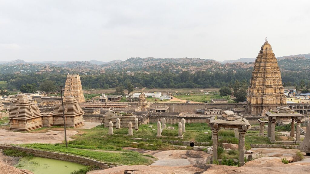
Virupaksha Temple Hampi
In this guide
- Three Karnatakas in one state
- The plateau and the rivers that crossed it
- The Chalukyas: Karnataka’s temple laboratory
- The Hoysalas: stone carved like jewellery
- Hampi: when a city became an empire
- Mysore: court culture after empire
- Haidar Ali, Tipu Sultan and resistance to British power
- The Karavali coast
- The Malnad and coffee country
- Kannada: another classical language
- The Western Ghats, Karnataka’s share
- Karnataka’s kitchen
- Silk, sandalwood and other crafts
- Bengaluru: from cantonment to tech capital
- Travelling Karnataka
Kerala’s story runs from mountains to sea. Tamil Nadu’s runs along rivers toward temple cities and a coastline that once launched a navy. Karnataka’s story is different again — because Karnataka isn’t really one geography at all. It’s three, folded into a single state, each producing its own kingdoms, crafts and way of life.
This guide follows the same principle established for Kerala and Tamil Nadu: geography first, culture as the consequence. Here, that means starting not with one chain but with a single mountain range that splits the state into three.
Three Karnatakas in one state
The Western Ghats run down Karnataka’s western edge much as they do through Kerala and Tamil Nadu further south, but here they create something slightly different: not just a wall between coast and interior, but a three-way split that shapes almost everything in this guide.
The coast: Karavali
West of the Ghats, a narrow, intensely green coastal strip — known locally as Karavali — faces the Arabian Sea, catching the same southwest monsoon that drenches Kerala. It’s a smaller, less internationally known version of that same coastal story: rice paddies, coconut palms, fishing communities and old port towns, with its own distinct language and culture rather than a simple extension of Kerala’s.
The Malnad: hill country
Immediately behind the coast, the Western Ghats rise into what’s locally called the Malnad, literally “hill country” — dense with forest and, at slightly lower elevations, some of India’s most significant coffee-growing regions.
The Deccan plateau
East of the Ghats, in the rain shadow, the land drops into the vast, considerably drier Deccan plateau that makes up most of Karnataka’s land area — black cotton soil, seasonal rivers, and a very different agricultural and political history from the coast and hills just a short distance away.
Three zones, three climates, three cultures — and, as this guide will show, three quite different sets of kingdoms and crafts, each shaped by its own particular relationship with the same mountain range.
The plateau and the rivers that crossed it
Karnataka’s Deccan plateau isn’t uniformly dry wasteland. It’s crossed by several major rivers, most significantly the Krishna and the Tungabhadra, which, much like the Kaveri further south in Tamil Nadu, created pockets of genuinely fertile, densely settled land capable of supporting ambitious kingdoms.
Black soil and dry farming
Much of the plateau is covered in regur, or black cotton soil, exceptionally fertile but dependent on seasonal rainfall rather than the kind of year-round water abundance found on the coast. Dry farming — cultivation adapted to rely on monsoon timing rather than constant irrigation — shaped settlement patterns here very differently from the intensively irrigated rice landscapes of the coast or the Kaveri delta in Tamil Nadu.
A corridor as much as a barrier
Because the plateau sits between North and South India, it has historically functioned as a corridor as much as a barrier — a zone where northern and southern political and cultural influences met, competed and blended, visible even today in Karnataka’s architecture, which borrows from both the northern Nagara temple style and the southern Dravida style more openly than almost anywhere else in India.
The Chalukyas: Karnataka’s temple laboratory
Long before the Hoysalas or Vijayanagara, the Badami Chalukya dynasty, ruling from around the 6th to 8th centuries CE from their capital at Badami (then called Vatapi), produced something unusual: not a single finished architectural style, but a genuine laboratory of experimentation that helped define how Indian temple architecture would develop for centuries afterward.
Badami’s cave temples
At Badami itself, Chalukya masons carved a series of rock-cut cave temples directly into a sandstone cliff face, combining Hindu and Jain shrines within a short walk of each other — an early, physically striking demonstration of religious coexistence under a single dynasty’s patronage.
Aihole and Pattadakal: architecture in draft form
A short distance away, Aihole contains well over a hundred temples built across several centuries, often described as a kind of open-air laboratory where Chalukya architects tried out different structural ideas before committing to their more refined versions elsewhere — early drafts, essentially, of forms that would later mature into the great temple traditions further south and north.
A style still deciding what it wanted to be
At nearby Pattadakal, a UNESCO World Heritage Site, temples built in the northern Nagara style stand within metres of others built in the southern Dravida style, constructed by the same dynasty around the same period — rare, direct physical evidence of two of India’s great temple traditions developing side by side rather than in isolation.
This experimental instinct — trying multiple structural solutions to the same problem, then refining the most successful ones — is part of what makes Chalukya sites feel different from the more settled, confident grandeur of the Chola or Hoysala temples that followed. You’re not looking at a finished architectural language. You’re looking at one being worked out.
The Hoysalas: stone carved like jewellery
Several centuries after the Chalukyas, the Hoysala dynasty, ruling roughly from the 11th to 14th centuries from their capital at Dwarasamudra (modern Halebidu), took Karnataka’s temple tradition in a direction almost the opposite of Tamil Nadu’s towering, imposing gopurams: extraordinary, almost obsessive intricacy of detail.
Soapstone as the key material
Hoysala temples were carved largely from soapstone (chloritic schist), a material soft enough when freshly quarried to allow extraordinarily fine detail — sculptors could achieve a level of ornamentation closer to jewellery-making than typical stone masonry, and the stone hardens with age and exposure, meaning the finest details actually harden into permanence after carving rather than needing to survive being cut from something already hard.
Belur and Halebidu
The Chennakeshava Temple at Belur and the Hoysaleswara Temple at Halebidu represent the tradition at its peak: star-shaped platforms, walls covered almost entirely in detailed friezes depicting mythological scenes, elephants, dancers and intricate floral and geometric patterns, and pillars famously said to have been lathe-turned to such precision that some can still be spun by hand today. Where a Chola gopuram overwhelms with sheer scale, a Hoysala temple rewards close, patient looking — the story is in the detail, not the height.
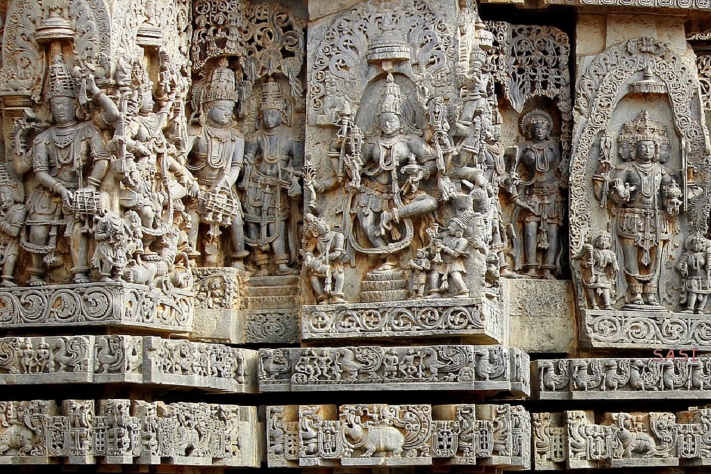
Belur Temple Carving
Hampi: when a city became an empire
If one place captures Karnataka’s Deccan plateau story most completely, it’s Hampi — not simply a set of ruins, but the remains of one of the largest and wealthiest cities in the world at its 16th-century peak.
Founding an empire on the frontier
The Vijayanagara Empire was founded in the 1330s, traditionally by two brothers, Harihara and Bukka, partly as a bulwark for southern Hindu kingdoms against the Deccan Sultanates expanding from the north. Its capital, built around the existing pilgrimage site of Hampi on the Tungabhadra river, grew over the following two centuries into an extraordinary imperial city.
Krishnadevaraya and the empire’s peak
Under Krishnadevaraya, ruling in the early 16th century, Vijayanagara reached its height — contemporary visitors, including Portuguese and Persian travellers, described a city of extraordinary wealth, with bustling markets selling diamonds, silk and horses, elaborate water-management systems supplying its temples, palaces and agricultural land, and a level of urban planning and infrastructure that genuinely astonished outside observers.
A market where diamonds were sold by the roadside
Foreign visitors to 16th-century Vijayanagara described bazaars so wealthy that gems were reportedly sold in the open street, weighed out casually rather than kept under careful guard — a detail that captures just how extraordinary the city’s peak-era prosperity genuinely was.
Water engineering on an imperial scale
Hampi’s rulers built stepped tanks, aqueducts and canal systems to supply water across the rocky, boulder-strewn landscape to temples, royal enclosures and farmland alike — the Pushkarani stepped tank and Vijayanagara-era canals still irrigating fields near the site today are physical evidence of engineering ambition matching the empire’s political and commercial reach.
The fall
In 1565, a confederacy of Deccan Sultanates decisively defeated Vijayanagara forces at the Battle of Talikota. The city was subsequently sacked and largely abandoned, its markets, palaces and temple complexes left substantially as ruins — a dramatic, sudden end that, unlike the slower fading of many empires, left an entire imperial capital essentially frozen in place for archaeologists and visitors ever since.
Today Hampi is a UNESCO World Heritage Site, its landscape of giant granite boulders scattered with temple ruins, the iconic stone chariot and musical pillars of the Vittala Temple, and the still-active Virupaksha Temple — which predates the empire itself and has continued functioning as a place of worship right through Vijayanagara’s rise, peak and fall, into the present day.
Hampi wasn’t slowly forgotten. It was ended, all at once, and left standing exactly where it fell.
Mysore: court culture after empire
When Vijayanagara fell, various regional families who had governed as its subordinates asserted independence — among them the Wadiyar dynasty, based at Mysore, who would go on to rule the Kingdom of Mysore, with some interruption, for roughly four centuries.
The Mysore Palace and Dasara
The current Mysore Palace (Amba Vilas Palace), rebuilt in its present Indo-Saracenic form in the early 20th century after a fire destroyed an earlier structure, remains the symbolic heart of the city, especially during Dasara, Mysore’s grand annual festival featuring an illuminated palace and a formal elephant procession — a tradition tracing back to the Vijayanagara court’s own Dasara celebrations, inherited and continued by the Wadiyars.
Silk and sandalwood
Mysore’s court patronage helped establish the region’s association with silk weaving and sandalwood craftsmanship, both still significant industries today — Mysore silk sarees remain among India’s most sought after, and sandalwood carving, though now working with more limited raw material than in earlier centuries due to conservation pressures, remains a genuine local craft tradition.
Haidar Ali, Tipu Sultan and resistance to British power
In the mid-18th century, Wadiyar authority was effectively displaced by Haidar Ali, a military commander who rose to control the Mysore kingdom in practice while the Wadiyars remained nominal rulers, and later by his son, Tipu Sultan, who ruled outright as Sultan of Mysore.
Four wars against the British
Between the 1760s and 1799, Mysore under Haidar Ali and then Tipu Sultan fought a series of four wars against the expanding British East India Company, representing some of the most serious and sustained resistance any Indian power mounted against British expansion in the 18th century.
Mysorean rockets
Tipu Sultan’s forces developed and deployed iron-cased military rockets — a genuine technological innovation for the period, more advanced than anything comparable in European arsenals at the time. British forces, having encountered these rockets in battle, subsequently studied and adapted the technology, directly influencing the development of the Congreve rocket in Britain shortly afterward — a rare instance of Indian military technology shaping European weapons development rather than the more familiar reverse.
Tipu was killed defending his capital at Seringapatam (Srirangapatna) in 1799, during the fourth and final Anglo-Mysore War, after which the British restored the Wadiyar dynasty to a reduced, British-supervised princely state that continued until Indian independence.
The Karavali coast
Karnataka’s own coastal strip, though smaller and less internationally known than Kerala’s, has its own distinct language, cuisine and history — not a lesser version of Kerala’s coast, but a genuinely separate one.
Tulu Nadu and Mangalore
Much of this coast falls within the historical and cultural region of Tulu Nadu, home to Tulu, a Dravidian language distinct from both Kannada and Malayalam, spoken by several million people. Mangalore (Mangaluru), the coast’s largest city, developed as a significant port under successive regional powers and later colonial control, its harbour connecting this stretch of coast to the same wider Arabian Sea trading world discussed in Kerala’s guide.
Udupi: temple and cuisine
Udupi, a mid-sized temple town on this coast, is home to the Krishna Matha, a major pilgrimage site, and gave its name to a distinct vegetarian culinary tradition — the “Udupi restaurant” format, built around dishes like idli, dosa and sambar, that spread from this specific coastal town to become one of the most recognisable South Indian food formats found across India and, eventually, well beyond it.
Yakshagana
The coast’s most distinctive performing art, Yakshagana, combines dance, music, elaborate costume and open-air night-long storytelling drawn from Hindu epics, performed by travelling troupes across the region — a coastal counterpart to the temple-rooted classical arts found further south in Tamil Nadu, though considerably more folk and community-based in character than Bharatanatyam’s classical, codified form.
The Malnad and coffee country
Immediately behind the coast, the Western Ghats rise into the Malnad, and it’s here, particularly in the districts of Kodagu (Coorg) and Chikkamagaluru, that Karnataka produces the large majority of India’s coffee.
Kodagu and the Kodava community
Kodagu is home to the Kodava people, a distinct community with their own language, customs and a notably strong military and sporting tradition — Kodagu has historically produced a disproportionate number of officers in the Indian armed forces relative to its small population, a source of considerable local pride.
How coffee reached the Ghats
Coffee cultivation expanded significantly across these hills under British colonial-era plantation agriculture in the 19th century, building on smaller-scale cultivation that reportedly predated colonial involvement, and Karnataka today remains India’s largest coffee-producing state by a wide margin, its Arabica and Robusta plantations forming a landscape genuinely comparable to Kerala’s highland tea country, though built around a different crop and community entirely.
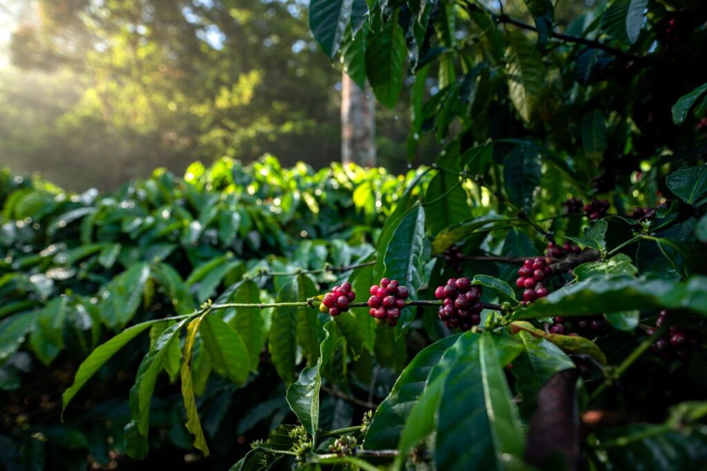
Coffee estate
Kannada: another classical language
Kannada, Karnataka’s official language, is — alongside Tamil — one of a small number of Indian languages formally recognised as a classical language by the Indian government, in recognition of its own ancient and continuous literary tradition.
The Vachana movement
Among Kannada literature’s most distinctive contributions is the Vachana tradition of the 12th century, associated closely with the philosopher-poet Basavanna and the broader Sharana movement — a body of vernacular devotional poetry that, notably for its time, argued against caste distinction and ritual orthodoxy in favour of direct personal devotion and the dignity of ordinary labour, composed in accessible spoken Kannada rather than Sanskrit.
That combination — a literary tradition old enough to be called classical, but built in places around genuinely progressive social ideas — gives Kannada literary identity a slightly different character from Tamil’s, even as both languages share the broader distinction of an unbroken tradition stretching back well over a thousand years.
The Western Ghats, Karnataka’s share
Karnataka holds a substantial portion of the same Western Ghats biodiversity hotspot discussed in the Kerala and Tamil Nadu guides, protected across several major reserves.
Kudremukh, Bandipur and Nagarhole
Kudremukh National Park protects a particularly dramatic stretch of rolling, grass-covered peaks and rainforest in the central Ghats. Further south, Bandipur and Nagarhole National Parks form part of the same greater Nilgiri-Western Ghats wildlife corridor described in the Tamil Nadu guide, holding significant tiger and elephant populations that move across the Karnataka-Tamil Nadu-Kerala tri-junction largely without regard for the state lines drawn across their habitat.
One range, three states, one continuous corridor
An elephant moving between Nagarhole in Karnataka, Mudumalai in Tamil Nadu and Wayanad in Kerala crosses two state borders without noticing — a reminder, echoed in each of this India Guide’s South Indian deep dives, that the Western Ghats function as a single connected ecosystem regardless of how the political map divides it.
Together with the coffee-growing Malnad hills just to their north, this stretch of Karnataka’s Ghats offers some of South India’s most substantial remaining wilderness, directly continuous with the reserves already described further south.
Karnataka’s kitchen
Karnataka’s food varies considerably across its three zones, but a handful of dishes are recognised across the state as distinctly Karnataka’s own.
Bisi bele bath and Mysore’s sweetness
Bisi bele bath, literally “hot lentil rice,” combines rice, lentils, vegetables and a distinct spice blend into one of the state’s most characteristic comfort dishes. Mysore Pak, a rich, ghee-heavy sweet reportedly developed in the Mysore palace kitchens, has become one of South India’s best-known desserts, its name now travelling far beyond the city that created it.
Ragi and the dry interior
In the drier plateau districts, ragi (finger millet) has traditionally played a role that rice plays on the wetter coast — ground into flour for rotis or balls (ragi mudde), or fermented into a tangy porridge — a direct dietary consequence of a climate better suited to a hardy dryland grain than to water-intensive rice cultivation.
Coorg’s different table
Kodagu’s Kodava cuisine stands apart from the largely vegetarian food traditions found elsewhere in the state, built around dishes like pandi curry, a distinctive pork preparation, reflecting the region’s separate cultural identity as clearly through food as through language and community history.
Silk, sandalwood and other crafts
Beyond Mysore’s silk and sandalwood, already mentioned, Karnataka holds several other distinctive craft traditions worth knowing about.
Bidriware
Bidriware, originating in the northern town of Bidar, is a distinctive metal handicraft technique in which an alloy is deliberately blackened through oxidation, then inlaid with fine silver or brass patterns that stand out sharply against the dark background — a technique reportedly developed under the Bahmani Sultanate that once ruled the region, and still practised by artisan families in Bidar today.
Craft as regional signature
Bidriware’s blackened, silver-inlaid style is specific enough to Bidar that the technique itself carries the town’s name internationally — a reminder that Karnataka’s craft traditions, like its architecture, are tied tightly to particular places rather than spread evenly across the state.
Channapatna toys
Channapatna, a small town near Bengaluru, has produced lacquered wooden toys for generations, a tradition with roots reportedly encouraged under Tipu Sultan’s patronage, using locally sourced wood and natural dyes — still a living craft economy today rather than a purely historical curiosity.
Bengaluru: from cantonment to tech capital
No Karnataka guide can end anywhere except Bengaluru, though the city’s story is considerably older than its current reputation as India’s technology capital suggests.
Kempe Gowda’s foundation
Bengaluru’s founding is traditionally credited to Kempe Gowda, a local chieftain governing under Vijayanagara authority, who established a fortified settlement here in the 16th century — a direct link back to the same empire whose ruins now sit at Hampi, several centuries and several hundred kilometres away.
Cantonment and Garden City
After the fall of Tipu Sultan, the British established a military cantonment alongside the existing city, and Bengaluru’s relatively mild climate, unusual for a South Indian city at this elevation, earned it a long-standing reputation as a comfortable retirement destination and, eventually, the nickname “Garden City.”
The Silicon Valley of India
That reputation shifted dramatically from the late 20th century onward. Early public-sector electronics and aerospace investment from the 1950s onward laid unexpected groundwork, and the software and IT services boom of the 1980s and 90s — with companies like Infosys, founded in 1981 and later headquartered in the city, among its most visible successes — transformed Bengaluru into India’s undisputed technology capital, a status the city has held ever since, alongside significant biotechnology, aerospace and startup sectors that have grown up around the same base.
A 16th-century Vijayanagara fort, a British cantonment prized for its climate, and a 21st-century global tech hub — all on the same patch of plateau.
It’s a genuinely striking arc to end on: a chieftain’s fort under a fading empire, a colonial garrison town prized for its weather, and a global technology hub, all occupying the same patch of Deccan plateau.
Travelling Karnataka
As with Kerala and Tamil Nadu, it’s more useful to group Karnataka the way its geography and history already do.
Practical notes
- Season. October to March is the most comfortable window across the plateau and coast alike; the coast and Malnad see the heaviest rain from June to September.
- Hampi needs real time. The site is large, spread across a boulder-strewn landscape with limited shade — plan at least a full day, ideally two, and avoid the midday heat where possible.
- Coffee estate homestays in Kodagu or Chikkamagaluru are genuinely worth the detour from a standard heritage circuit, offering a very different pace from the temple and fort sites elsewhere in the state.
- Bengaluru’s traffic is notoriously heavy — build real time into any itinerary that includes the city, rather than assuming distances on a map translate directly into travel time.
- The heritage circuit spans real distances — Hampi, Badami and Belur aren’t close together, so this is a multi-day journey rather than a single-base trip.
Perhaps next in the South India deep dive: Andhra Pradesh and Telangana, the Telugu-speaking Deccan east — Karnataka’s neighbour across the plateau.
Curious about Hampi, Karnataka’s coffee country, or Bengaluru firsthand? Message me on WhatsApp.