India Guide — Central India
The Heartland: Rivers, Kingdoms and Belief
Not one landscape, but the place where several meet — rivers, plains and plateaus that made this the part of India where kingdoms rose, cities grew, and some of the country’s most enduring ideas took shape.
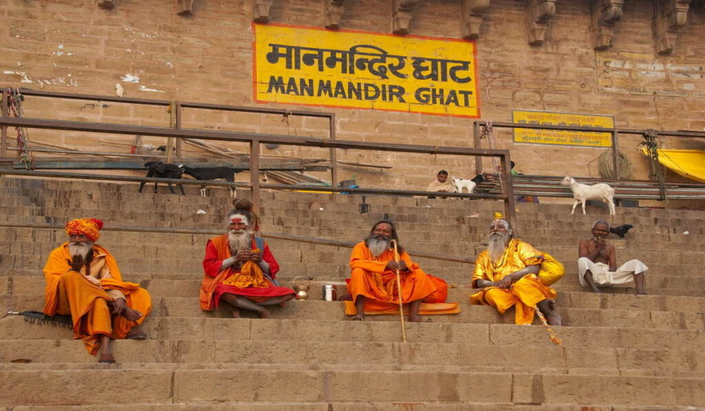
Varanasi Ghat
In this guide
- The land where rivers meet
- The Ganga — a river that became a civilisation
- The Yamuna — one river, two worlds
- Why cities grew here
- Food is geography you can taste
- The Narmada, and the hills that divide
- Forests and Adivasi India
- When Buddhism changed the landscape
- Sacred geography, and Varanasi
- Empires, courts and refinement
- Khajuraho: what temples tell us
- 1857, and the modern heartland
- There is no single Central India
- Travelling the Heartland
“Central India” is a slightly misleading name, and worth setting straight before anything else. This isn’t one landscape wedged between the more famous ones. It’s the place where several landscapes and river systems physically meet — and where a large share of what most people think of as “Indian history” actually happened.
If Rajasthan’s story is scarcity, and South India’s is the sea, this region’s story is the opposite kind of abundance: rivers, fertile plains and dependable water created the conditions for permanent settlement, and permanent settlement is where kingdoms, cities, pilgrimage and philosophy all had room to grow.
Almost everything below traces back to that one condition.
The land where rivers meet
Before Uttar Pradesh and Madhya Pradesh as administrative units, there’s the terrain itself: the Indo-Gangetic plain running across the north, the Yamuna basin threading through it, the Chambal ravines cutting a harder edge south of Agra, the Bundelkhand uplands, the Malwa plateau, and the Vindhya and Satpura ranges running roughly east-west — the geological seam where north India starts becoming south India. West of the Vindhyas, the Narmada valley runs its own course entirely.
That’s not one landscape. It’s several, stitched together by water.
Every region in this guide series has its own version of that arrow. In the desert, water scarcity forced caravans and fortified towns. On the coast, the sea forced ports and maritime trade. Here, the opposite pressure applied: water was reliable enough, often enough, that people could stay in one place for centuries — and staying in one place is what allows a village to become a city, and a city to become a capital.
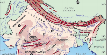
Map — Central India explained
The Ganga — a river that became a civilisation
It undersells the Ganga to call it India’s longest river. A more honest description: it’s simultaneously a physical resource, an agricultural lifeline, a sacred entity, a pilgrimage route and a cultural symbol — all at once, for the same body of water, without any contradiction felt by the millions of people who live along it.
That layering is worth sitting with, because it’s the key to understanding why a river can become sacred in the first place. It isn’t decoration added on top of a practical resource. The practical and the sacred grew up together — agriculture, settlement, mythology and ritual all took root along the same banks, at the same time, reinforcing each other for thousands of years.
Once you see the Ganga that way, Varanasi stops being strange and starts making sense.
A river can be physical geography, agricultural resource and sacred entity at once — without contradiction.
The Yamuna — one river, two worlds
Don’t let the Ganga’s fame swallow the Yamuna — it earns its own chapter, because it tells two almost unrelated stories depending on which stretch of it you’re standing beside.
Follow it through Mathura and Vrindavan, and it’s the river of Krishna — childhood, devotion, colour, the Bhakti tradition at its most exuberant. Follow it through Delhi and Agra, and it’s an entirely different river: the water that Mughal emperors built capitals and gardens beside, the river the Taj Mahal actually faces.
Same river. Completely different cultural worlds, a short drive apart. That’s a pattern worth watching for across the whole region.
Why cities grew here
Varanasi, Prayagraj, Mathura, Agra, Delhi, Gwalior, Bhopal, Indore, Ujjain, Lucknow, Kanpur — rather than treat this as a list to memorise, it’s worth asking the same question of each one: why did people build a city exactly here?
The answers repeat, in different combinations: water, fertile land for feeding a large population, a river crossing or trade route, a defensible position, or a pilgrimage site that pulled in enough visitors and patronage to sustain a permanent settlement around it. Political power tended to follow, rather than lead — rulers built capitals where the underlying economic and religious geography already made a city viable, not the other way around.
That’s the difference between memorising a list of cities and actually understanding why the map looks the way it does.
Food is geography you can taste
The fertile northern plains built an agricultural base around wheat, rice, pulses, sugarcane, dairy and vegetables — and cuisine here, as everywhere else in this guide series, follows agriculture rather than the other way around.
Uttar Pradesh’s food carries a strong Awadhi and Mughlai layer — wheat breads, dairy-rich gravies, kebabs, biryani, an entire etiquette built around how a meal is served. Madhya Pradesh’s food is plainer and, in places, more resourceful: wheat and pulses in the plains, millets and forest produce in the tribal belts, poha as a Malwa breakfast staple, dal-based cooking that reflects a less courtly, more agrarian history.
Put simply: food is geography you can taste — and in this region, you can taste the difference between a Mughal court and a village on the Malwa plateau in a single meal.
The Narmada, and the hills that divide
Not every sacred river in India flows toward the Bay of Bengal. The Narmada runs west, between the Vindhya and Satpura ranges, toward the Arabian Sea — and it carries its own, largely separate religious identity, with pilgrimage towns like Maheshwar and Omkareshwar built along its banks rather than the Ganga’s.
The Vindhya and Satpura ranges that frame it matter for more than scenery. Historically they’ve shaped where armies could march, where political boundaries settled, where forests and tribal communities remained largely undisturbed by the plains kingdoms, and where trade routes had to detour around rather than through. In a real sense, this is where north India and south India negotiate with each other — not quite either, a transition zone with its own logic.
Guide’s note
If South India’s monsoon story was “the two coasts don’t even get wet at the same time,” the Heartland’s equivalent is this: too little water brings hardship, too much brings floods, and it’s the reliable middle — not the extremes — that actually built civilisations here.
Forests and Adivasi India
It would be easy — and wrong — to tell this region’s story entirely through kings, temples and Mughal courts. A large part of Central India’s identity, particularly in Madhya Pradesh, belongs to communities whose histories aren’t written into royal monuments at all: Gond, Bhil and Baiga communities among others, with their own forest economies, art traditions, and long-standing relationships with land that predate most of the empires discussed elsewhere in this guide.
This is India beyond the monuments, and it’s worth actively looking for rather than treating as a footnote.
🌿 A wellness thread
Much of India’s traditional plant knowledge — medicinal herbs, forest remedies, dietary wisdom — has roots in exactly these forest communities and agrarian traditions, feeding into wider systems like Ayurveda over centuries. It’s another layer sitting quietly under the history, the same thread that runs through the food and pilgrimage sections here.
When Buddhism changed the landscape
Long before any of the temples or forts most visitors come to see, this region was central to a much larger intellectual shift. Under Ashoka and the Mauryan empire, Buddhism spread outward from here with real institutional force — monasteries, stupas, pilgrimage networks, an entire infrastructure built to carry ideas rather than armies.
Sanchi’s stupa is the physical survivor of that movement — not a monument in isolation, but the visible remainder of a period when this region helped export a philosophy to most of Asia.
Sacred geography, and Varanasi
Ujjain, Omkareshwar, Chitrakoot, Mathura, Vrindavan, Ayodhya, Prayagraj — each of these became sacred for a slightly different reason: something believed to have happened there, a place’s relationship to a wider sacred landscape, or simply centuries of accumulated pilgrimage that made the place sacred by repetition. That’s a genuinely useful idea for a traveller to carry through the rest of India, not just this region.
Varanasi: when a city becomes a pilgrimage
Varanasi earns its own space rather than a mention inside the river section. The ghats, the cremation grounds, the daily rhythm of bathing and prayer along the Ganga — all of it is real, ongoing religious practice, not a display staged for visitors.
The single most important thing to understand before arriving: Varanasi isn’t a museum. People live there — birth, death, commerce and devotion happening in the same streets, often within view of each other, all day, every day.
Varanasi isn’t a museum. People live there.
Empires, courts and refinement
From here the history moves into a dense run of empires and courts, and the useful approach isn’t a list of rulers — it’s asking what each left behind that a traveller can still see.
The Mughal period reshaped huge parts of this region administratively, architecturally and culinarily — Agra, Delhi and Fatehpur Sikri are the clearest evidence, but the imprint runs through language, gardens and food as much as monuments. Further east, Awadh and its capital Lucknow built something different again: Lucknow is where refinement itself became a culture — Urdu poetry, Hindustani music, an entire etiquette (tehzeeb) around hospitality and conversation, and a cuisine of slow-cooked kebabs built to match. Meanwhile Bundela rulers at Orchha, and later Maratha power through the Scindia and Holkar dynasties at Gwalior and Indore, built their own architectural and cultural worlds across the Malwa plateau and Bundelkhand — proof that this region’s political story was never only a Mughal one.
Look closer
Indian architecture here is rarely one culture replacing another cleanly. It’s usually layers accumulating — a Buddhist site absorbed into a Hindu pilgrimage landscape, a Rajput fort later occupied by Mughal or Maratha rulers, an Islamic dome sitting over a temple’s original foundation. Look for the layer underneath the obvious one.
Khajuraho: what temples tell us
Khajuraho gets reduced, almost automatically, to “the erotic temples” — which is a real part of the sculptural programme, but a small one, and treating it as the whole story misses what actually makes the site remarkable.
The carvings at Khajuraho cover an entire spectrum of medieval life: gods and myth, yes, but also daily life, music, dance, warfare, courtly scenes, and — as part of that same continuum — sexuality. Read together rather than singled out, they’re less shocking and considerably more interesting: a fairly complete visual record of what a medieval Indian court considered worth carving in stone for eternity.
1857, and the modern heartland
This region is essential to understanding 1857 — the uprising the British called a Mutiny and many Indians call the First War of Independence, a difference in framing that’s worth knowing about before you visit any of the sites themselves. Meerut, Delhi, Kanpur, Lucknow, Jhansi and Gwalior all carry direct physical evidence of it: the Residency ruins in Lucknow, memorials in Jhansi and Gwalior, contested plaques and stories that read differently depending on who wrote them.
It didn’t end there, either. This isn’t only India’s past. Uttar Pradesh alone carries one of the largest populations of any political unit on earth, and cities like Lucknow, Kanpur, Bhopal and Indore are where a huge share of India’s present — its industry, its universities, its urban growth, its politics — is actually being lived out, not just remembered.
Woven through all of it, worth naming rather than skipping past: large extended family networks that remain central to daily life; religion as everyday practice rather than an occasional observance; a genuine social expectation around hospitality toward guests; a sharp difference between the India a traveller sees in a major city and the India just outside it; and caste, which has historically structured social life across this region and continues to shape it for many people today, even as modern India has seen significant legal change, affirmative action and — especially in cities — real generational shift. It’s a subject that deserves care rather than either silence or sensationalism.
There is no single Central India
Two states, two rather different characters, both genuinely part of the same river-shaped story:
Uttar Pradesh
The Ganga and Yamuna at their most historically dense — Varanasi, Prayagraj, Mathura, Agra, Lucknow, Ayodhya. Mughal and Awadhi refinement, enormous population, and India’s religious geography at its most concentrated.
Madhya Pradesh
The Narmada, the Vindhyas and the Malwa plateau — Sanchi, Khajuraho, Orchha, Gwalior, Ujjain, Maheshwar, Omkareshwar. Older Buddhist and Adivasi layers, Bundela and Maratha courts, and a quieter, more forested version of the same story.
Seen together, the wider India Guide’s organising idea gets a little clearer:
Rajasthan
Scarcity
South India
Sea & monsoon
Central India
Rivers & abundance
Northeast
Mountains & borders
Not a random set of regional brochures — an answer, each time, to the same underlying question: what force shaped this part of India, and where do you still see it today?
Travelling the Heartland
The practical layer, after all the context above:
- When to go. October through March is far kinder than the heat of May–June or the peak monsoon months; Varanasi and Khajuraho in particular are much more comfortable outside summer.
- How long to spend. A focused ten to twelve days lets you properly combine one Uttar Pradesh route with one Madhya Pradesh route, rather than rushing both.
- Good routes. Delhi → Agra → Gwalior → Orchha → Khajuraho covers Mughal, Bundela and temple history in one line. Delhi → Mathura → Agra → Lucknow → Varanasi runs the Yamuna-to-Ganga arc, courtly to sacred. Bhopal → Sanchi → Ujjain → Indore → Maheshwar → Omkareshwar traces the Narmada and the Buddhist and pilgrimage layers together.
- Road vs. train. Trains connect the major cities well and are often the more interesting way to travel; a car and driver make more sense for Khajuraho, Orchha, Sanchi and Maheshwar, which sit further off the rail network.
- Religious etiquette. Modest dress at temples and ghats regardless of heat; ask before photographing cremation ceremonies in Varanasi — this isn’t a performance, and it’s someone’s grief.
- Heat and dress. Summers here run genuinely hot; light, breathable, modest clothing works better than anything else, in cities and at religious sites alike.
- What to expect. This is a denser, more historically layered stretch of travel than most regions in India — fewer beach afternoons, more standing in front of something six hundred years old trying to take it in.
None of this needs memorising before you land. It just helps to know it’s coming.
Rivers built the plains. Kingdoms built the cities. Belief is what’s kept it all alive.
Thinking through a route across Uttar Pradesh and Madhya Pradesh — or wondering how much time Varanasi, Khajuraho or the Narmada temple towns actually deserve on your itinerary? Message me on WhatsApp.